Google Mobile Maps’ “My Location” from cell signal triangulation is fairly neat. It’s a few hundred meters off my true location downtown, but good enough if you were completely lost.
Tag: maps
-
wiggly
Can I just say that the road from Busch to Eureka Springs, Arkansas is the most gratuitously wiggly route I’ve ever driven?
Our route down from Kansas City was longer than I thought; place not blind trust in GPS routing, especially when you’re close to the edge of the maps you’ve uploaded. Due to one wrong turn on my part, we ended up in Overland Park, KS — rather than being on Hwy 71 all the way south. In future, I shall upload all the maps I need, plus all the states/provinces surrounding, so you don’t get that terra incognita/here be dragons feeling of falling off the edge of your wee scrolly map.
-
neat, but quite last summer …
Toronto Public Library Finder; nice, but I was so on that game months before …
-
you go, Glen!
Congratulations are due to Glen Estill, who got his two Vestas V82s on the Bruce Peninsula running today. Glen is a pioneer of wind energy in Ontario, and we’re all grateful to him for his tireless work for the industry.
Update: further to my wind turbines from space obsession, I found Glen’s original V80 turbine at 44° 56′ 46.42″ N, 81° 15′ 47.12″ W.
-
worst geolocate ever
Never had my GPS being so far out. It used to say here was 28.59742, -81.21251, but now it’s saying 28.59603, -81.21274. That’s about 150m off.
-
east coast, but further west
Strange to think that I’m on the east coast, but actually further west than home in Toronto. That whole curving away to the Gulf of Mexico thing will get you if you’re not careful.
The strange thing is, if you take my current longitude, and the latitude of our house, you get a point near Rte 16 near Brussels, ON that I’ve been through on the way back from the wind farm. That’s like, y’know, stuff, and some like other stuff too, whoah!
-
Here do books lurk
Catherine has a project involving Toronto’s libraries, and so I, for no particularly good reason, compiled a geocoded list of the Toronto Public Library system: libraries.gpx
You can thank MapSource for the bloated GPX file. It quadrupled in size when I changed the symbols to look like buildings.
-
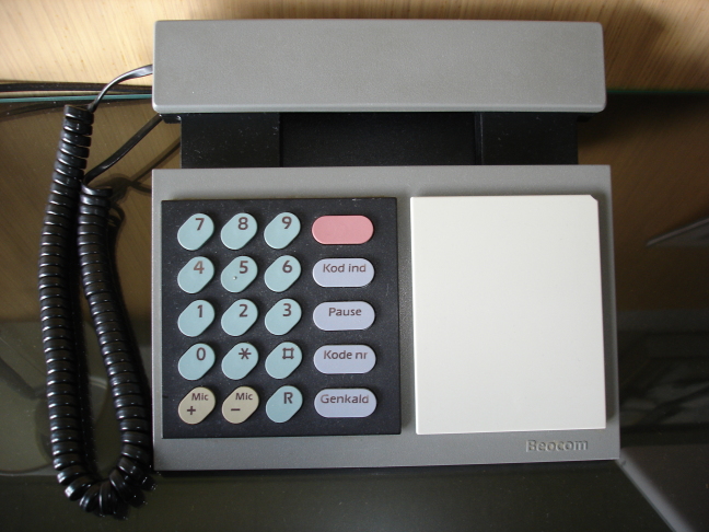
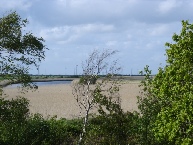
Danish Modern in Ringkøbing
I’m currently checked into a hotel which reeks of 70s Danish modern — blonde wood, bare brick, smoked glass surfaces — and, like many places in Denmark, cigarette smoke. Being in the presence of an authentic Beocom phone makes up for it though:
Also, there’s a cute little wind farm outside; a few Vestas V27s (or smaller) on lattice towers at 56° 7′ 22.11″ N, 8° 13′ 48.94″ E:
-
in Aalborg
I like Aalborg. I think we’re staying in exactly the same hotel (the Scandic) as I stayed in 10 years ago with RES. We’re going to see some really big wind turbines tomorrow.
Oh, and the Google Maps locations I picked off for this hotel are pretty darn accurate; the one I double-clicked on for this hotel is less than 50m from my room. I like.
-
geo mashup
I should probably introduce my Geo Mashup page. It shows where I’ve been blogging from, using Google Maps. It’s quite a fun WordPress plugin,and you can get it here.
-
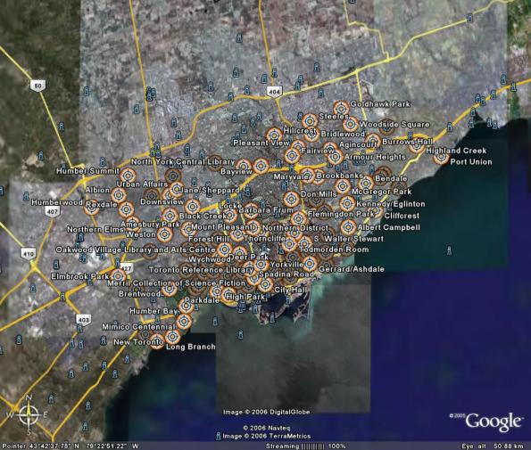
Toronto Subway Station GPS Locations
After seeing the various nifty web-enabled transit maps, I realised I had the data handy to get things started. A while back, I georeferenced the TTC Ride Guide, and digitized all the station locations. I cleaned them up today, and in the hope of being useful, here are the files:
These are simple three-column CSV files, stating latitude, longitude, and station name. They should be in order of stations. Locations are probably within about 50m of real life, but don’t bank on it.
I’ll get these into more useful formats soon, like GPX and KML. For now though, if you can use ’em, go ahead and do something.
-
Stewart’s long walk
After picking up my UK passport form at Bay & College, I walked to Spadina Subway. Not far, you’d say. It is if you go via College all the way to Dufferin, and back. 7.3 km, I make it, from the amazing Gmaps Pedometer. I went via Canada Computers (where I got a fantastically quiet Vantec case fan) and Soundscapes (where, of course, I bought too many CDs).
And you know why it was such a long walk? I was looking for a Timmy’s. Sad, isn’t it? It would seem that Little Italy is almost totally free of Tim’s. Yes, I know I could have had fantastic espresso and some kind of pastry there, but I wanted Tim’s, and I was prepared to walk for over an hour in sub-zero temperatures to get it, dammit.
-
big windfarm, big deal
So there was a stramash that the RSPB published a map showing where the Lewis wind farm would reach if it started in Edinburgh. Oh noes! Looks like it’d go all the way to Methil.
I’ve been working on a couple of medium-sized wind farms in Ontario. For top laughs, I tried overlaying them on Scotland, using streetmap.co.uk for the measurements.
Since I’m a weegie, I started at George Square. One of the farms would stretch all the way west by Wishaw, near Murdostoun Castle (and the comically-named town of Bonkle). The other would run north to somewhere between Fintry and Kippen, in Stirlingshire.
For those of you unlucky enough to be based east of Falkirk, I tried the same starting at Edinburgh Castle. The first wind farm would run west to the hamlet of Gilchriston, which is just north-west of Dun Law Wind Farm, which I worked on in the distant past. (If you run the farm west from Edinburgh, you end up in Bo’ness, which no-one would want to do.) The other design would end up somewhere between Kirkcaldy and Glenrothes, near Thornton — and not that far from Methil, a distance that the RSPB would have us believe is just too far for a wind farm.
So, where’s the news, RSPB? How did your land get somehow more precious than ours?
-
blog entry for dad
My folks have been visiting for the last couple of weeks (we’re just about to leave for the airport), and Dad asked for some links we discussed. The following will probably make little or no sense to other readers:
- Google Maps UK, including a link to a place they’ll know well.
- The Caravel Web Content Management System, from the Mennonite Church.
- AVG Anti Virus.
- Tax Refund for Visitors to Canada, the official fee-free one.
- Collected Works of Caruso.
-
pech pech
I cycled out to the end of Leslie Street Spit this evening. It’s far. I got to the concrete pad by the lighthouse: Google Maps: Leslie St Spit: 43.61374° N, 79.34352° W.
My legs hurt. A lot. But it was pretty. I saw one of the beaver-felled trees, too.
-
it’s cold, it’s pointy, it’s 70°32’S 64°57’W!

via the ever-wonderful Fourmilab‘s Earth and Moon Viewer, an image from QuickBird 2.For once, Google Maps’ version isn’t as pretty.
-
wind turbines from space
Update April 2007: I’ve created a Google My Maps page for these locations: Wind Turbines from Space.
Messing about with Google Maps, I went looking for wind turbines. And yup, you can see ’em:
- Pickering, Ontario: Vestas V80, by Pickering Nuclear Power Station. You can see this quite clearly.
- Toronto, Ontario: maybe I’m imagining I can see the WindShare turbine.
Update, 3rd May: following my posting to awea-windnet, I got three more:
Thanks to David Wright for the California location, and Joe Duddy of RES (my old employer!) for the two from England. I’ve spent quite a bit of time on the latter two windfarms.
Update, 6 May: Found a couple more windfarms from space on googleglobetrotting.com:
- near Livermore, California.
- east of Tehachapi, California — dig the arrangement of blades in the boneyard.
Update, 20 June: Google now has worldwide coverage.
- Tarifa, Spain
- Middelgrunden, København, Denmark (offshore)
- somewhere else in Denmark — these are big turbines.
Update, 29 June:
- McBride Lake, Alberta — image taken while in construction. You can see the tower sections and the blades laid out. You can even make out the crane installing one of the northern turbines. This is a Vision Quest Windelectric project.