Windows has just spent the last 15 minutes searching for a driver for my Garmin GPS. Y’know, the one I use with the computer a lot. It’s claiming it’s new hardware, but in the words of Syd, “I’ve had it for months”. Oh Windows, you really are very stupid. In fact, you are a silly wizard.
Tag: garmin
-
worse than no map at all
I’ve been using my GPS to track roads around the wind farm.
I’m most disappointed with the coverage that Garmin’s MetroGuide Canada gives. Sure, Ashfield-Colborne-Wawanosh might not be Canada’s most vibrant metropolis, but it seems that much of the MetroGuide routing is screwy around the Huron shores. A couple of frinstances:Hwy 21 around Goderich is about 100-300m of its location, and the junction from Hwy 8 is almost a kilometre out. The GPS does an amusing “Hey, make a turn … whoa, how’d you get here?” kind of thing as you come into Goderich.According to MetroGuide Canada, you are “Arriving at Lucknow” when you’re on Hwy 21. Lucknow’s almost 20km from Hwy 21. It also doesn’t seem to know about routing along Hwy 86, and also tries to route you across an entirely imaginary road near Belgrave Road.Visiting friends near Wingham last night, the GPS suggested I should go back to Goderich via Clinton, a detour of 20km.
I know I didn’t really need to use the GPS for this (except I now know how to navigate the backroads of Wingham), but some of the map choices it was giving me were downright useless.Helps if you load the right map …
-
eBay.ca: Garmin Geko 201 GPS plus extras
I’m selling my Garmin Geko 201 GPS plus extras on eBay (item 320106781450). I’ve been very happy with it, and the only reason I’m selling it is because I just upgraded to a GPSMap 60CSx. Dave has a similar unit, and I was very impressed with the way it handled routing when we drove around Vancouver.
Most of the reviews of the unit seem to be pretty on the mark: accurate location, quick acquisition, and an ability to find a signal with little or no skyview. While the 60CSx does appear to work indoors, it suffers from weird track jitter.
-
Here do books lurk
Catherine has a project involving Toronto’s libraries, and so I, for no particularly good reason, compiled a geocoded list of the Toronto Public Library system: libraries.gpx
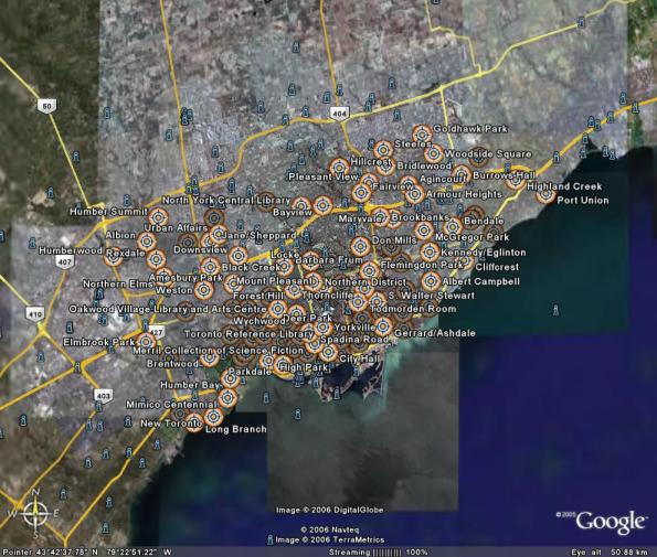
You can thank MapSource for the bloated GPX file. It quadrupled in size when I changed the symbols to look like buildings.