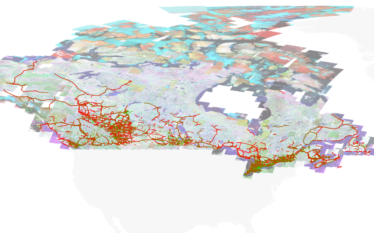
 Made using scruss/taflmunge and QGIS.
Tag: map
-
it looks like Scotland’s sneezing …
 I think that IfItWereMyHome.com needs to work on its tracing of the UK.
(via)
-
trying to determine whether my side of the tracks is the right one
My neighbourhood, Kennedy Park, is pretty much defined by the CNR tracks at the southeast and northwest corners. This is Toporama Web Map Service data overlaid on the toronto.ca | Open neighbourhood polygon:

It’s all lit up! These are the houses in my streets, each one highlighted in QGIS:

More GIS nerdry at Numpty’s Progress. -
this is rather good
BWEA – Google Map of all UK wind farms – wonder if we can do the same for CanWEA?
-
um, no …
This is really part of a route suggested by Google Maps:
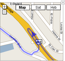
6. Take the exit onto HWY-402 W toward Sarnia (102 km)
7. Make a U-turn (0.3 km)It should be noted that the 402 is a large highway, and u-turns are not exactly recommended.
-
you go, Glen!
Congratulations are due to Glen Estill, who got his two Vestas V82s on the Bruce Peninsula running today. Glen is a pioneer of wind energy in Ontario, and we’re all grateful to him for his tireless work for the industry.
Update: further to my wind turbines from space obsession, I found Glen’s original V80 turbine at 44° 56′ 46.42″ N, 81° 15′ 47.12″ W.
-
worst geolocate ever
Never had my GPS being so far out. It used to say here was 28.59742, -81.21251, but now it’s saying 28.59603, -81.21274. That’s about 150m off.
-
east coast, but further west
Strange to think that I’m on the east coast, but actually further west than home in Toronto. That whole curving away to the Gulf of Mexico thing will get you if you’re not careful.
The strange thing is, if you take my current longitude, and the latitude of our house, you get a point near Rte 16 near Brussels, ON that I’ve been through on the way back from the wind farm. That’s like, y’know, stuff, and some like other stuff too, whoah!
-
Here do books lurk
Catherine has a project involving Toronto’s libraries, and so I, for no particularly good reason, compiled a geocoded list of the Toronto Public Library system: libraries.gpx
You can thank MapSource for the bloated GPX file. It quadrupled in size when I changed the symbols to look like buildings.
-
AWEA06: by the river (or in it, nearly)
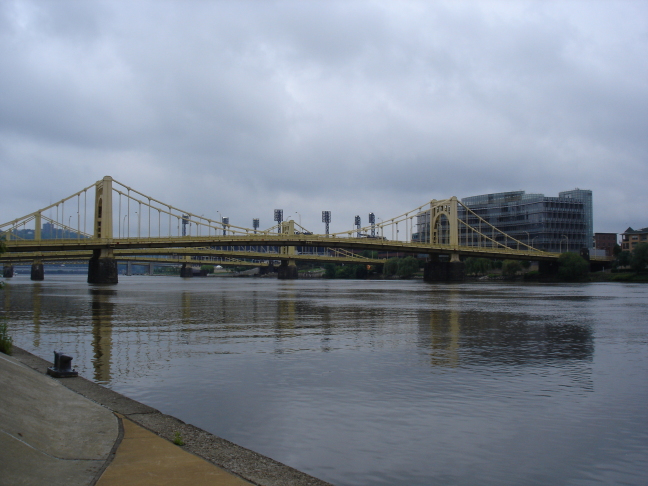
We’re not getting the best weather for the conference, but I hear that the coincidentally-running Three Rivers Arts Festival has had rain 18 out of the 20 years it has run, so noone’s surprised.
Conference hasn’t quite started yet, but the preliminary swag is quite promising; yoyos and balsa aircraft.
I spent the day in workshop run by KidWind, who have a school science kit for teaching the basics of wind turbine effectiveness. We got to build wind turbines, and test them. Here’s mine, big wean that I am:
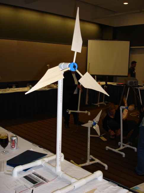
I guess I got some losses near the hub there, but at least it worked. I was the only developer type there (there was a DoE person, and lots and lots of Pennsylvania teachers). I came away impressed, and hope I can work with Michael Arquin of KidWind to bring the project to Ontario.
(This post has the worst GPS location ever; could only get a fix to within 100m, so that’s why the map location appears to be in the river.)
-
Pittsburgh: I’m only hea for AWEA
In town for the AWEA 2006 Conference. Pittsburgh looks like it has some interesting topography, and has some huge buildings downtown. Trying to get a GPS signal for the map (amid a bemused high-school prom crowd) was hard.
-
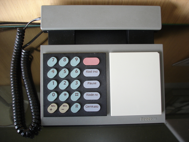
Danish Modern in Ringkøbing
I’m currently checked into a hotel which reeks of 70s Danish modern — blonde wood, bare brick, smoked glass surfaces — and, like many places in Denmark, cigarette smoke. Being in the presence of an authentic Beocom phone makes up for it though:
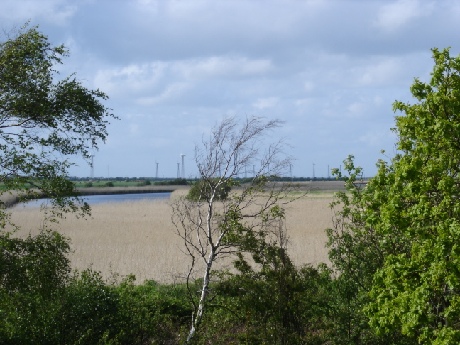
Also, there’s a cute little wind farm outside; a few Vestas V27s (or smaller) on lattice towers at 56° 7′ 22.11″ N, 8° 13′ 48.94″ E:
-
in Aalborg
I like Aalborg. I think we’re staying in exactly the same hotel (the Scandic) as I stayed in 10 years ago with RES. We’re going to see some really big wind turbines tomorrow.
Oh, and the Google Maps locations I picked off for this hotel are pretty darn accurate; the one I double-clicked on for this hotel is less than 50m from my room. I like.
-
blackberry lost and found
GPS is good. I was walking this huge field, and somewhere in the middle dropped my BlackBerry. I can’t follow tracks for toffee, but with the GPS track map set to high resolution, I found it.
-
geo mashup
I should probably introduce my Geo Mashup page. It shows where I’ve been blogging from, using Google Maps. It’s quite a fun WordPress plugin,and you can get it here.
-
Toronto Subway Station GPS Locations, now in GPX
Further to Toronto Subway Station GPS Locations, I now have them in GPX format: ttc.gpx. Google Earth reads GPX files, but loses some of the metadata.It would seem that someone has done this before, but using a different approach. I did search the forums, but there were no stations in the community overlay — honest, guv.
-
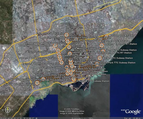
Toronto Subway Station GPS Locations
After seeing the various nifty web-enabled transit maps, I realised I had the data handy to get things started. A while back, I georeferenced the TTC Ride Guide, and digitized all the station locations. I cleaned them up today, and in the hope of being useful, here are the files:
These are simple three-column CSV files, stating latitude, longitude, and station name. They should be in order of stations. Locations are probably within about 50m of real life, but don’t bank on it.
I’ll get these into more useful formats soon, like GPX and KML. For now though, if you can use ’em, go ahead and do something.
-
Stewart’s long walk
After picking up my UK passport form at Bay & College, I walked to Spadina Subway. Not far, you’d say. It is if you go via College all the way to Dufferin, and back. 7.3 km, I make it, from the amazing Gmaps Pedometer. I went via Canada Computers (where I got a fantastically quiet Vantec case fan) and Soundscapes (where, of course, I bought too many CDs).
And you know why it was such a long walk? I was looking for a Timmy’s. Sad, isn’t it? It would seem that Little Italy is almost totally free of Tim’s. Yes, I know I could have had fantastic espresso and some kind of pastry there, but I wanted Tim’s, and I was prepared to walk for over an hour in sub-zero temperatures to get it, dammit.
 Well, I liked it …
