Catherine and I just had lunch at Queen of Sheba on Bloor just east of Dufferin. It was good; gentle spices and tons of flat bread to eat the meat and sauces with.
I can’t believe I have never had Ethiopian food before. I shall remedy that soon.
work as if you live in the early days of a better nation
Catherine and I just had lunch at Queen of Sheba on Bloor just east of Dufferin. It was good; gentle spices and tons of flat bread to eat the meat and sauces with.
I can’t believe I have never had Ethiopian food before. I shall remedy that soon.
The GTA Bloggers will be meeting tonight on the second floor of Paupers Pub on Bloor, just east of Bathurst at 6:30 pm. Be there, or not.
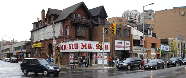
This corner of Bloor & Bedford is about to be gone:

It has memories for us, as the first place we stayed when we arrived was just up the road. Breakfast was at Country Style (which became a Booster Juice after the massive Tim’s opened across the road), lunch was from Pita Factory, the daily paper from Gus at the Mac’s, dinner was sometimes at Swiss Chalet #1; all on the same block, all going to be gone.
If you look at the bigger picture, you’ll see that hugin neatly severed a couple of heads. It might smart a little, but with some bactine and gauze, it’ll grow back in the morning.
After seeing the various nifty web-enabled transit maps, I realised I had the data handy to get things started. A while back, I georeferenced the TTC Ride Guide, and digitized all the station locations. I cleaned them up today, and in the hope of being useful, here are the files:
These are simple three-column CSV files, stating latitude, longitude, and station name. They should be in order of stations. Locations are probably within about 50m of real life, but don’t bank on it.
I’ll get these into more useful formats soon, like GPX and KML. For now though, if you can use ’em, go ahead and do something.
Oh dear, another bike lane project: Take the Tooker! – Bloor Danforth bike lane. I much prefer to go play in the traffic.