Will it be dry in time for the conference?
Look, fair dos, I don't live in Glasgow in any more. I now haunt East Dunbartonshire, so I don't get into town as much as I might. If any of these examples ever gets upgraded you must e-mail me, as good work must be rewarded.
Content updated (and © Stewart C. Russell) 10 September 02001
Picture updated 9 September 02001
Will it be dry in time for the conference?
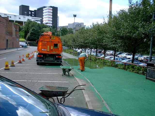
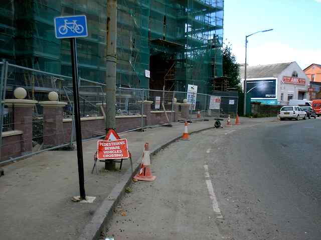
With just a week to go until Velo City 2001 lots of bizarre green patches are still appearing on the roads and pavements. I think these are supposed to be bike lanes, but they aren't wide enough, and not properly placed for visibility. Worst of all, when the lanes cross the pavements, there's nothing to tell the pedestrians that bikes have right of way there. All it would take is a too-fast cyclist meeting a too-slow granny, and cyclists would be Public Enemy #1 again.
Things are fractionally better than they were in the city a couple of years ago. At least some of the routes have signs. But generally there isn't a network of routes; there are bits and pieces all over the place, and no overall plan. Where facilities are shared-use (sadly, all too often) there are few clues to help pedestrian expect cyclists. Where bike lanes are on roads, they're only advisory, so thoughtless galoots can park their powered prams on them.
Oh, and before you go, "He's just another of those whiny cyclists; can't even be bothered to complain through the proper channels..." --- I have. Several times. At best, I get a generic reply which misses the point. At worst, I get a letter aflame with incandescent rage, berating me for my audacity to complain. I just want proper facilities for cyclists, so that we're not embarrassed to show Velo City delegates around them.
By the way, it's worth reading the ALT fields that appear if you let the mouse pointer hover over the pictures...
Visit last year's version of ths page from June 2000; some things have changed. Some things have not.
Picture updated 9 Sep 02001
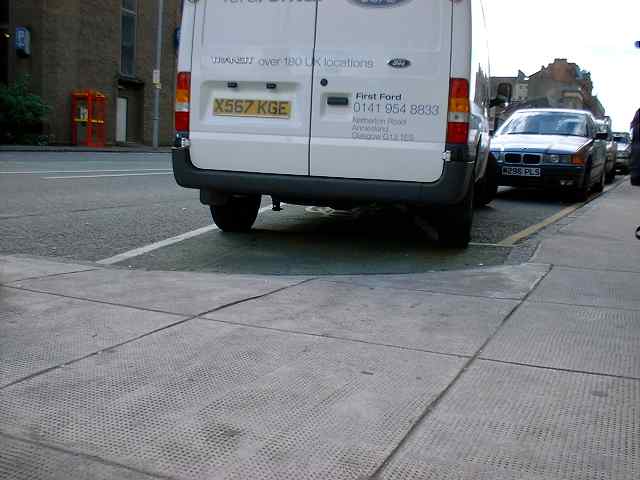
Cambridge Street: This drop-kerb has been dropped a bit more to make it less of a bump. Getting over the Transit van would be more of a problem.
Picture updated 20 Jun 2000, checked 9 Sep 02001
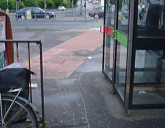
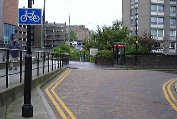
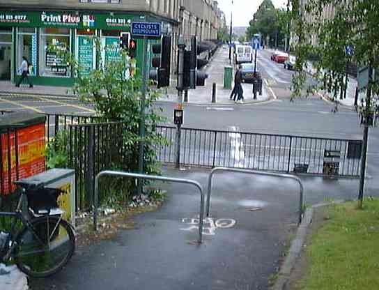
Buccleuch Street: I doubt that phone box users would expect cyclists to scoot by so close, and "doorings" might occur. This may or may not be a bike lane; who can say from nearby signs?
Picture updated 9 Sep 02001
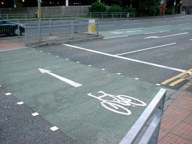
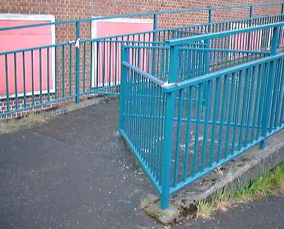
Cambridge and Cowcaddens: this ped crossing, not (yet?) a toucan, has become a bike lane. But the lane out at top right is blocked by a railing and a bollard. And it's been like this since at least June of last year.
Here's another of the same thing:
Picture updated 9 Sep 02001
Actually, I like this facility so much, I've dedicated a special page to it. Bask in its uselessness.
Picture updated 9 Sep 02001
Cowcaddens Road: I'm told this is a shared-use path. There are no signs to tell any of the users that. So I get the evil eye if I cycle on it, as peds (rightly) don't expect me to be there.
In 1996, Go Bike members designed the Colleges Cycle Route. This was a proposal for a bike route linking the higher learning facilities in the north of the city. The city took it on, and officially opened it in late 1999.
I decided to follow it to see if I could, and to see what Go Bike's dream had become.
Picture updated 20 Jun 2000, checked 9 Sep 02001
Cowcaddens Road at Port Dundas Road: this lane narrows, then splits at a junction, then feeds into an advance stop line (ASL) at the traffic lights.
Picture updated 20 Jun 2000
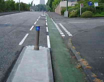
McPhater Street, by the Piping College: there's no clue as to where you're supposed to go here. The keen-of-eye might spot a greenish patch by the trash can. This peters out half way down the pavement, leaving you confused as to where to go.
Picture updated 20 Jun 2000
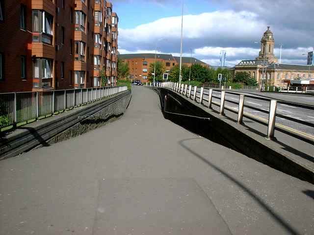
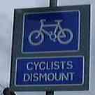
New City Road ped fly-over: this has a bike chicane with such a slope and camber it makes you fall off. There's no CYCLISTS DISMOUNT sign here; it wouldn't be an instruction, more a statement of fact.
Picture updated 20 Jun 2000
Pushing to West Prince's St: at the end of the ped fly over, we have to deal with this; get off and walk. I must be confusing this with a cycle route, where you kind of get to pedal every now and then.
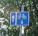
West Prince's St has occasional blue bike signs, but it doesn't tell you where you're supposed to turn into Montague Street, and then on to Park Road
Picture updated 9 Sep 02001
University Avenue: Traffic seems slightly more use to bikes curving to the right now. But there's still no lane heading up the hill, where one would be useful.
I have been this -> <- close to being doored on University Avenue up on the hill. Beware of narrow roads and dozy drivers in a hurry.
Picture updated 20 Jun 2000, checked 9 Sep 02001
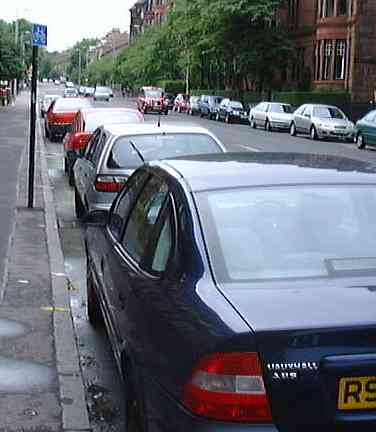
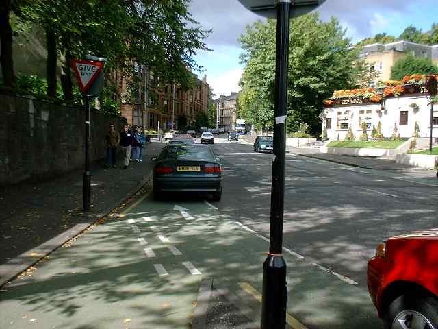
Highburgh Road "car park": I cycled past this line of cars before I realised it was supposed to be a bike lane. Some driver education is needed here.
Someone can put me right on this, but as these lanes have dashed lanes, they're only advisory, so drivers can do pretty much anything they want in them. Seems a shame to spend money on something that's rendered useless by a few cars.
Picture updated 9 Sep 02001
Highburgh Road again: See how just one driver can mess everything up. There's a semi-nice special junction for bikes, but a driver of The Safest Car In Its Class (not if yer hit by one, bucko) was just too clever.
Picture updated 20 Jun 2000, checked 9 Sep 02001
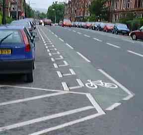
Crow Road: What's this doing here? This is, in fact, quite a nice cycle lane. Notice the strip separating you from the car doors. It also asserts your place in the road. So this is in no way a crappy lane. It would have been great if the lanes on Highburgh Road were like this.
The trouble is, however, that this part of the Colleges Route wasn't in the original Go Bike design. It missed out Clarence Drive and Crow Road (with its horrific junction) entirely, taking you down the quiet Hughenden Lane and Shelley Road.
Picture updated 9 Sep 02001
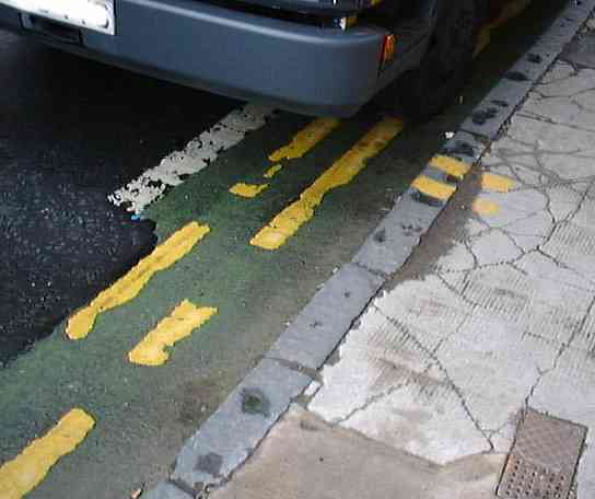
As it stands, the lanes on Clarence Drive get parked on by shoppers, rental vans, and traffic for the Post Office depot.
Picture updated 20 Jun 2000, checked 9 Sep 02001
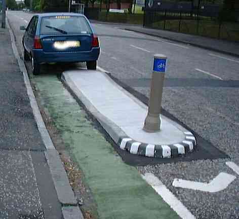
Southbrae Drive: see how one thoughtless driver can destroy a well-intentioned cycle facility. This guy was parked here last year; seems he has a grudge against cyclists. Now if this had been a mandatory lane:
Picture updated 20 Jun 2000, checked 9 Sep 02001
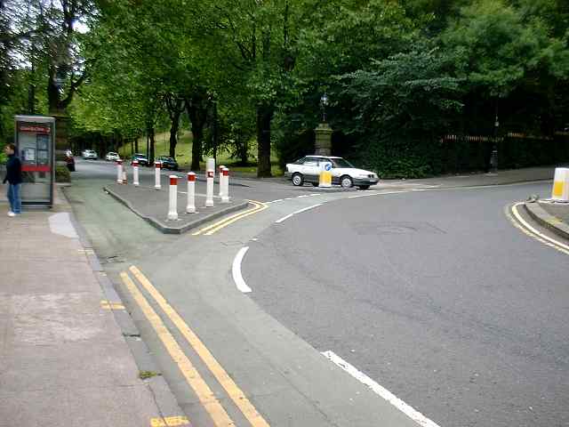
Southbrae Drive: it looks to me that traffic coming out from this junction would tend to use the edge of the lane marked out by the islands as their stop line. This would help their visibility, but block cyclists, who really should be further out at junctions so drivers can see them.
Picture updated 20 Jun 2000, checked 9 Sep 02001
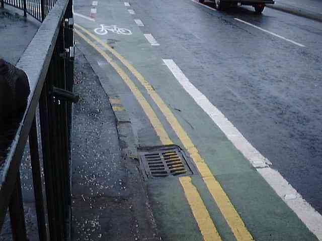
Allison St at Victoria Rd, heading east: This looks like a pretty standard kerbside advance stop line (ASL) entry lane, if there wasn't a great huge truck parked in it. The only thing (apart from the truck) is, it's only around 65cm wide from the kerb to the outside edge of the white line. The kerb is where glass bottles go to die, and hence no place for cyclists.
While there isn't always a truck parked in the lane, I noticed that there's a bike lane sign nearby that the diagram of the lane is almost the same size as the one on the road. They're not meant to be to scale, folks...
Picture updated 20 Jun 2000, checked 9 Sep 02001
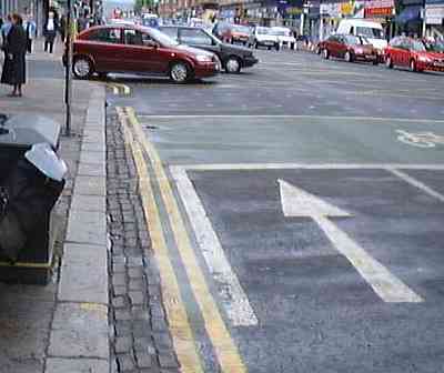
Victoria Rd at Allison St, heading south: This one's really special. Not merely is it the same width (65cm, kerb to outside of white line) as the one on Allison St, but half its width is taken up by cobblestones. A couple of metres back from the end of this are car parking spaces, so the chances of getting into this ASL in the correct way are nil. Good work, Glasgow!
In a letter from the Director of Land Services on 28 April 1999, the council says:
. . . the advanced stop lines at Victoria Road and Allison Street are well used by cyclists. Local cycle-user groups have endorsed the Council's practice . . . and are keen that this practice is extended throughout the city.
To which a well-known Glasgow bike activist very succinctly replied:
Yes, it's true that Go Bike endorses the practice of ASLs, but it doesn't endorse the practice of sh*te ones!
Picture updated 20 Jun 2000, checked 9 Sep 02001
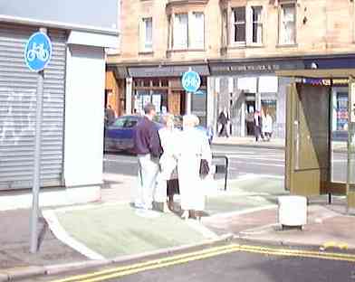
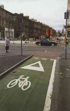
Victoria Road "pavement patches": What are all these green patches on the pavement, like this one behind the bus stop at Bowman St? Drop-kerb bike lanes aren't such a good idea for those of us with narrow tyres. How are we supposed to maintain a decent speed (and sight line) here -- especially when members of the Strathbungo Social Club use it as a gathering place.
Picture updated 30 Mar 1999, checked 20 Jun 2000 and 9 Sep 02001
Torrisdale St at Pollokshaws Road: You have to climb a tiled hump to get out of the lane. Why?
Picture updated 20 Jun 2000, checked 9 Sep 02001
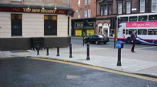
Lane & Toucan at Nithsdale Rd and Pollokshaws Rd: On a wide pavement at the blocked end of Nithsdale Road, a vaguely greenish bike lane does a dog-leg. It gets very close to the wall of the 'New Regent' pub, which helpfully blocks the remaining pavement with its dumpster. It's interesting to note that the 'bike sign' bollard was a later addition, causing more blockage than when the lane was put in.
I consider the toucan crossing dangerous, as southbound cars from Pollokshaws Road can still turn into Torrisdale Street while the cycles and peds have the crossing.
Picture updated 20 Jun 2000, checked 9 Sep 02001
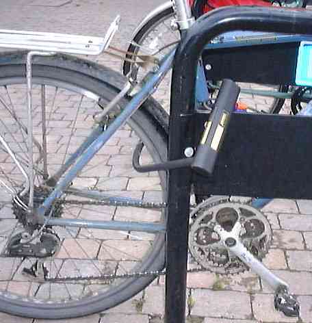
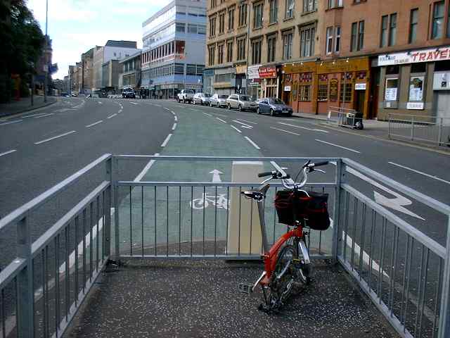
Lock block: Have you noticed that the many new Sheffield-style racks that have appeared (for which, thanks) have a crossbar (for which, no thanks) that stops you locking through the frame and the rear tyre? It's at exactly the right height to get in the way. It's also too high to be felt by a blind person's cane, which is why many of these stands have crossbars.
(I'd like to point out that I have cleaned my chain since that photograph was taken.)
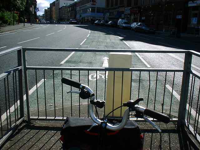
Presto-change-o! See how to instantly double the amount of bike lane by making what was a safe one way bike lane by the side of the Citizens Theatre into an unsafe two way! And all by the use of inexpensive road signs!
Picture updated 20 Jun 2000
East End of Cleland St: Looks like a bike lane going solely west, even if it is on the wrong side of the road, because it's so narrow. If you met something going east, it would be difficult to pass.
Picture updated 20 Jun 2000
Middle of Cleland St: but a sign half way along says it's eastbound. Who to believe?
The council seems to be unaware that this lane has been signed as two way. They think that it's still just a contraflow lane. Maybe they should get on their bikes and see what their contractors are doing in their name.
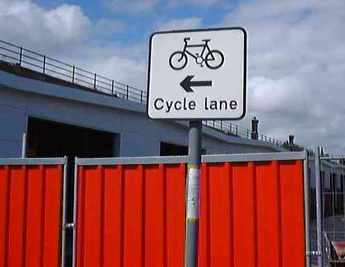
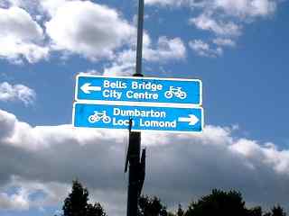
There's a very useful sign on a completely open piece of road just south of Bell's Bridge:
Picture updated 20 Jun 2000, checked 9 Sep 02001
Why do we never see DRIVERS GET OUT AND PUSH?
Picture updated 9 Sep 02001
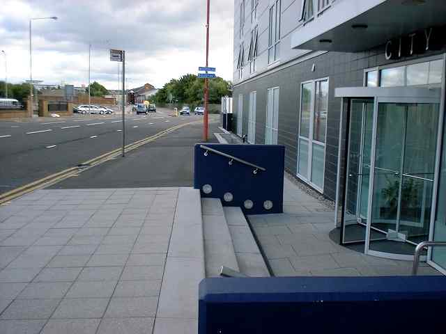
Pointhouse Quay has the new City Inn, with a fetching terrazzo tiled section outside it. This is reportedly lethal in the wet, and there's nothing to tell the cyclist or the ped what to expect. Let's just wait for the first lawsuit.
Picture updated 9 Sep 02001
Give me a sign: North of the SECC and Bell's Bridge, NCN 7 takes a sharp right over Pointhouse Road. We used to have to rely on the efforts of a helpful bloke who'd written the directions on the bridge in what looked like Tippex®; now we have signage!
Picture updated 9 Sep 02001
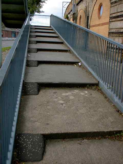
Stairway to Heaven (not): The Pointhouse bridge now has little wedges to help you wheel your bike up it. This would be good if:
Actually, wouldn't it to be too much to be able to cycle this? After all, it is supposed to be a cycle route, not a "push your bike around" route?
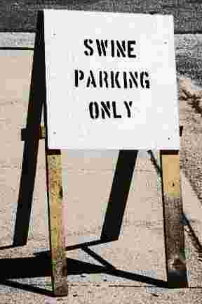 Good Parking...!
All it takes is just one thoughtlessly-parked motor vehicle to completely destroy the purpose of an advisory bike lane. Here are some examples:
Picture updated 9 Sep 02001
Cambridge Street
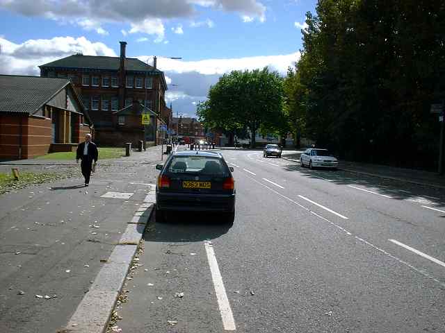
Govan Road
Highburgh Road
Southbrae Drive
(My apologies to swine everywhere; pigs are intelligent and sociable.)
So we're stuck with these things now, and they're all shiny bright for our international visitors. But is there a budget to maintain them? Is there a cleaning budget to keep them glass-free? Will more (and better) facilities go in once Velo City 2001 is just a memory of a hangover? Or will Glasgow cyclists be abandoned again?
The best we can do is try to convince the Velo City delegates that it's all a massive surrealist prank. Hey, come with me to a sensible place!
Picture updated 9 September 02001
While there are many highly visible attempts to build cycle facilities in Glasgow, there are still considerable barriers to progress. More and better work is needed.
*: Best said with a Sean Connery accent.