Here’s a bike ride around my neighbourhood rendered in QGIS using Bing Maps imagery via OnTerra Bing Maps WMS Service:

(via)
work as if you live in the early days of a better nation
Here’s a bike ride around my neighbourhood rendered in QGIS using Bing Maps imagery via OnTerra Bing Maps WMS Service:
(via)

Just spent a pleasant morning munging gps data and photos using Prune. It has allowed me to edit a complex GPS track, add many photos, correctly correlate them to GPS locations, and save it all back out in a variety of useful formats.
I see that the author is talking about producing a native KDE version. Noooo! I like my Java. It runs everywhere.
(Incidentally, I see that with the recent software update, the Blackberry Curve will now geotag images from the camera. It’s now a really good “I was here” device – coming close to the “Utensil” that Robyn Hitchcock spoke about years ago.)
I like bbtracker -it’s a very simple GPS track logger for the Blackberry. It has (at least, at the current version) one problem – you can’t create waypoints in the way that most GPS applications would expect. You can, however, name trackpoints – so I wrote a little perl script to extract all the named trackpoints from an exported GPX files, and save them as waypoints.
Download bbtrackerwpt – converts named trackpoints from bbtracker GPX into waypoints. You’ll need XML::Simple for this to work.
I imagine this script has a limited audience, and quite likely a limited lifetime. The author of bbtracker has said they’d provide waypoint support in the next version. You know me and patience, though …
If I remembered more XSLT, I’d have done this the proper way. As is, I create XML using Perl print statements. I’m probably okay, as the name field is the only piece of free-form text, and I do some rudimentary escaping of characters that XML doesn’t like. The output seems to validate, which is more than the GPX that bbtracker produces does. The length of your GPS track may vary 😉
Can I just say that the road from Busch to Eureka Springs, Arkansas is the most gratuitously wiggly route I’ve ever driven?
Our route down from Kansas City was longer than I thought; place not blind trust in GPS routing, especially when you’re close to the edge of the maps you’ve uploaded. Due to one wrong turn on my part, we ended up in Overland Park, KS — rather than being on Hwy 71 all the way south. In future, I shall upload all the maps I need, plus all the states/provinces surrounding, so you don’t get that terra incognita/here be dragons feeling of falling off the edge of your wee scrolly map.
Windows has just spent the last 15 minutes searching for a driver for my Garmin GPS. Y’know, the one I use with the computer a lot. It’s claiming it’s new hardware, but in the words of Syd, “I’ve had it for months”. Oh Windows, you really are very stupid. In fact, you are a silly wizard.
For the upcoming midwestern trip, I’d ordered some Mapsource maps from GPS Central to help navigate across the mitten. They said they were in stock; indeed, they still do at time of writing:

I was very disappointed to get a note today saying that they were really out of stock, and they can deliver after the time I need it. GPS Central had previously been great, but they let me down by misrepresenting on their website. I cancelled the order.
Prairie Geomatics came to the rescue. They’re shipping tomorrow, for the same price (and cheaper shipping). I spoke to a real person to confirm.
I’ve been using my GPS to track roads around the wind farm. I’m most disappointed with the coverage that Garmin’s MetroGuide Canada gives. Sure, Ashfield-Colborne-Wawanosh might not be Canada’s most vibrant metropolis, but it seems that much of the MetroGuide routing is screwy around the Huron shores. A couple of frinstances:
I know I didn’t really need to use the GPS for this (except I now know how to navigate the backroads of Wingham), but some of the map choices it was giving me were downright useless.
Helps if you load the right map …
I do a lot of work with UTM survey locations, and quite often I want to have them stored in my GPS. I used to rely on a powerful but oh-so-clunky Windows application called Corpscon, but I really didn’t want to be limited to Windows machines, and Corpscon really only works for North America.
And then I discovered proj. While it has a pretty hideous command-line syntax, the output matches Corpscon to the sixth decimal place. Say you had a waypoint stored (for Southern Ontario, UTM Zone 17, NAD83) like this:
4843744 443025 Goderich
that is, UTM northing,easting, followed by label.
To convert this to geographic coordinates, you’d invoke invproj (which goes from UTM to geographic) like this:
invproj -E -r -f "%.6f" +proj=utm +zone=17 +datum=NAD83
and it would spit out:
4843744 443025 -81.707611 43.744546 Goderich
Columns 3 and 4 are the geographic coordinates – 43° 44′ 40.37″ N, 81° 42′ 27.40″ W in more familiar notation – which is in fact a location between Brock St and Newgate St in Goderich, Ontario.
With a Unix box, proj and gpsbabel, I’m set for all my coordinate conversions.
The USB data transfer works flawlessly from the GPSMap 60CSx to GPSBabel.
Never had my GPS being so far out. It used to say here was 28.59742, -81.21251, but now it’s saying 28.59603, -81.21274. That’s about 150m off.
We’re not getting the best weather for the conference, but I hear that the coincidentally-running Three Rivers Arts Festival has had rain 18 out of the 20 years it has run, so noone’s surprised.
Conference hasn’t quite started yet, but the preliminary swag is quite promising; yoyos and balsa aircraft.
I spent the day in workshop run by KidWind, who have a school science kit for teaching the basics of wind turbine effectiveness. We got to build wind turbines, and test them. Here’s mine, big wean that I am:
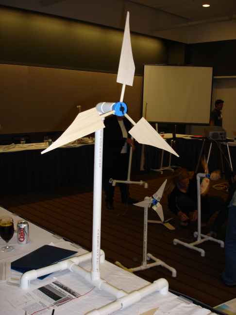
I guess I got some losses near the hub there, but at least it worked. I was the only developer type there (there was a DoE person, and lots and lots of Pennsylvania teachers). I came away impressed, and hope I can work with Michael Arquin of KidWind to bring the project to Ontario.
(This post has the worst GPS location ever; could only get a fix to within 100m, so that’s why the map location appears to be in the river.)
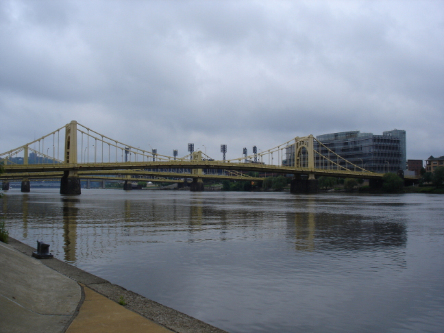
In town for the AWEA 2006 Conference. Pittsburgh looks like it has some interesting topography, and has some huge buildings downtown. Trying to get a GPS signal for the map (amid a bemused high-school prom crowd) was hard.
GPS is good. I was walking this huge field, and somewhere in the middle dropped my BlackBerry. I can’t follow tracks for toffee, but with the GPS track map set to high resolution, I found it.
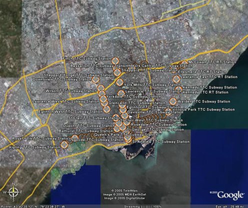
Further to Toronto Subway Station GPS Locations, I now have them in GPX format: ttc.gpx. Google Earth reads GPX files, but loses some of the metadata.
It would seem that someone has done this before, but using a different approach. I did search the forums, but there were no stations in the community overlay — honest, guv.
After seeing the various nifty web-enabled transit maps, I realised I had the data handy to get things started. A while back, I georeferenced the TTC Ride Guide, and digitized all the station locations. I cleaned them up today, and in the hope of being useful, here are the files:
These are simple three-column CSV files, stating latitude, longitude, and station name. They should be in order of stations. Locations are probably within about 50m of real life, but don’t bank on it.
I’ll get these into more useful formats soon, like GPX and KML. For now though, if you can use ’em, go ahead and do something.